


fours 2012

yt34
User
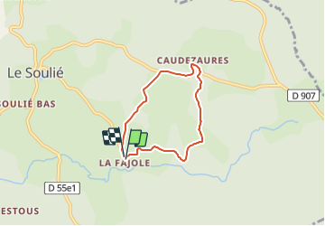

Length
5.2 km

Max alt
955 m

Uphill gradient
106 m
Km-Effort
6.6 km

Min alt
874 m

Downhill gradient
101 m
Boucle
Yes
Creation date :
2014-12-10 00:00:00.0
Updated on :
2014-12-10 00:00:00.0
--
Difficulty : Very easy

FREE GPS app for hiking
 SityTrail
IGN / Geographical institutes
SityTrail Plus
The world is yours!
About
Trail Walking of 5.2 km to be discovered at Occitania, Hérault, Le Soulié. This trail is proposed by yt34.
Description
itinéraire pédestre La Fajole Caudezaures
Positioning
Country:
France
Region :
Occitania
Department/Province :
Hérault
Municipality :
Le Soulié
Location:
Unknown
Start:(Dec)
Start:(UTM)
476274 ; 4820714 (31T) N.
Comments